
My recent visit to Cromer in Norfolk for the Walkers Are Welcome annual get-together was short, but I squeezed in some exploration of the local coast.
When I arrived on the Friday afternoon (12 October) I found I had a spare hour and so set off eastwards, through the town to Warren Woods at the top of the cliffs.

The path to Warren Woods, east of Cromer
Soon I came to the impressive lighthouse.

Lighthouse
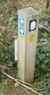
The path along the cliffs from this point is labelled as permissive, across the golf course.

Permissive-path sign
This I find puzzling. The route on the Ordnance Survey map is on the cliff top and although some of it may have fallen down the cliff, part of it appears to remain. It is marked on the map as the Paston Way but unfortunately this (and the England Coast Path) has been routed along the beach, omitting some of the finest cliffs in Norfolk which are over 70 metres high.

The cliffs east of Cromer

The view towards Overstrand
The view was lovely, and below the woods tumbled down the cliffs

Woods at the foot of Overstrand cliffs
I wished I had more time, but I had to turn back for the Walkers Are Welcome reception.
To Sheringham
The next day I slipped away to walk to Sheringham, on a glorious October afternoon in the good company of Randal and Pat Metzger and John Sparshatt from Otley in west Yorkshire. We had hoped to walk on the clifftop all the way, but the coast is debased by mobile homes and caravan parks, pushing the path inland.
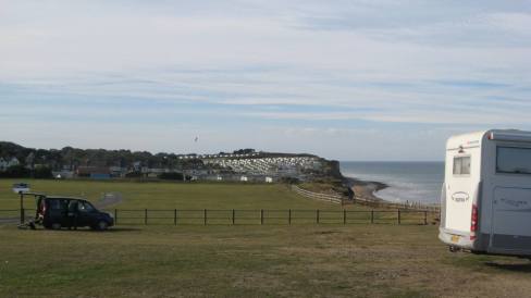
West of Cromer we are forced inland by the caravan parks
After negotiating a caravan park we had to resort to the busy A149 to East Runton where we turned down to the beach. The tide was out and we walked under the cliffs towards Sheringham, admiring the geological strata.

On the beach
We reached Water Lane and were able to go back onto the clifftop; the Laburnum caravan park sign is not particularly welcoming, but there is a small waymark. This is the England Coast Path.

Not the most welcoming sign
National trail waymark
We came to Beeston Bump, which is part of the Cromer ridge, glacial moraine left when the glaciers retreated northwards at the end of the last ice age, 10,000 to 15,000 years ago. It was a signals intelligence post, known as a ‘Y station’ during the World War II.

Beeston Bump from the west
From the bump we had a view over Sheringham.

Sheringham from Beeston Bump
Randal and Pat decided to return to Cromer by public transport (there is a train and bus); John and I wanted to walk back. We returned along the coast with a view east to Beeston Regis church, spoilt by the caravans in the foreground.

View to Beeston Regis church
We decided to take the old Norfolk Coast Path national trail’s inland route. We crossed the railway and the A149 and entered woodlands, part of Beeston Regis heath owned by the National Trust.

Soon we came to Beacon Hill, at 105 metres the highest point in Norfolk.
Beacon Hill looking north
Next we reached Congham Hill common, recognisable because it was marked as a small area of access land on the Ordnance Survey map. We went to the top, though it was a tricky scramble through deep bracken and brambles with not much view.

On top of Congham Hill common
A bit further on we passed under the fine bridge on the Cromer Curve, the railway line between Norwich and Cromer.

Railway bridge on the Cromer Curve
And so we returned to Cromer for our evening entertainment, after a pleasant and varied walk. It is sad that some of the coast is degraded by caravans and made inaccessible, and that the named routes tend to follow the beach rather than the clifftops.

Cromer church

Yes, I have walked this section of the North Norfolk coast path and it does seem a shame that the England coast path apparently does so little to enhance the walking routes – and indeed is barely visible to the casual walker. We need to pick this up in a concerted way = or should we wait to the remaining sections are in place. Maybe then it is difficult to get things changed
Agree, need to think what’s best.
A grand stretch of coast though the paths need sorting out.
It’s a lovely area to walk in. I remember seeing the no hang-gliding sign near the golf course when I walked there last year. It’s the only sign like that I’ve seen so far on East Anglian coastal paths, though there are several beware of flying golf balls signs! 🙂
That’s no public footpath under the Cromer Curve: Newstead’s Lane must be a restricted byway judging by the size of the railway bridge,